
Thank you for supporting this site ❤️
Make a donation
Make a donation
Mount Cline topographic map
Click on the map to display elevation.
Thank you for supporting this site ❤️
Make a donation
Make a donation
About this map
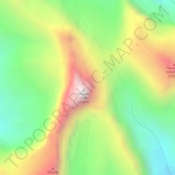
Name: Mount Cline topographic map, elevation, terrain.
Location: Mount Cline, Clearwater County, Alberta, Canada (52.06947 -116.68374 52.06957 -116.68364)
Average elevation: 2,696 m
Minimum elevation: 2,221 m
Maximum elevation: 3,340 m
Thank you for supporting this site ❤️
Make a donation
Make a donation
Other topographic maps
Click on a map to view its topography, its elevation and its terrain.
Thank you for supporting this site ❤️
Make a donation
Make a donation
Cutoff Creek Equestrian Staging Public Land Recreation Area
Canada > Alberta > Clearwater County
Average elevation: 1,509 m
Thank you for supporting this site ❤️
Make a donation
Make a donation
Hummingbird Public Land Recreation Area
Canada > Alberta > Clearwater County
Average elevation: 1,830 m
Thank you for supporting this site ❤️
Make a donation
Make a donation