
Kinsangani topographic map
Interactive map
Click on the map to display elevation.
About this map
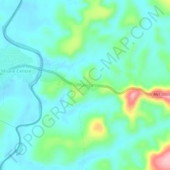
Name: Kinsangani topographic map, elevation, terrain.
Location: Kinsangani, Kwilu, Democratic Republic of the Congo (-4.81472 17.53264 -4.77472 17.57264)
Average elevation: 392 m
Minimum elevation: 357 m
Maximum elevation: 518 m
Other topographic maps
Click on a map to view its topography, its elevation and its terrain.
Penanga
Democratic Republic of the Congo > Kwilu > Kwilu
Penanga, Kwilu, Democratic Republic of the Congo
Average elevation: 458 m
Bampum Lakenakwa
Democratic Republic of the Congo > Kwilu > Kwilu
Bampum Lakenakwa, Kwilu, Democratic Republic of the Congo
Average elevation: 412 m
Kikwit
Democratic Republic of the Congo > Kwilu > Kwilu > Kikwit
Kikwit, Kwilu, Democratic Republic of the Congo
Average elevation: 459 m
Mulashi
Democratic Republic of the Congo > Kwilu > Kwilu > Mulashi
Mulashi, Kwilu, Democratic Republic of the Congo
Average elevation: 466 m