
Thank you for supporting this site ❤️
Make a donation
Make a donation
Joe Pool Lake topographic map
Click on the map to display elevation.
Thank you for supporting this site ❤️
Make a donation
Make a donation
About this map
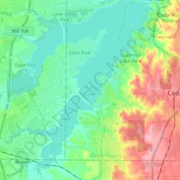
Name: Joe Pool Lake topographic map, elevation, terrain.
Average elevation: 186 m
Minimum elevation: 150 m
Maximum elevation: 268 m
Thank you for supporting this site ❤️
Make a donation
Make a donation
Other topographic maps
Click on a map to view its topography, its elevation and its terrain.
South Westchester Meadows
United States > Texas > Dallas County > Grand Prairie
Average elevation: 156 m
Thank you for supporting this site ❤️
Make a donation
Make a donation
South Westchester Meadow
United States > Texas > Dallas County > Grand Prairie
Average elevation: 158 m