
South Westchester Meadow topographic map
Interactive map
Click on the map to display elevation.
About this map
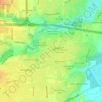
Name: South Westchester Meadow topographic map, elevation, terrain.
Average elevation: 158 m
Minimum elevation: 140 m
Maximum elevation: 172 m
Other topographic maps
Click on a map to view its topography, its elevation and its terrain.
Westchester Valley
United States > Texas > Dallas County > Grand Prairie
Westchester Valley, Grand Prairie, Dallas County, Texas, 75054, United States
Average elevation: 158 m
Joe Pool Lake
United States > Texas > Dallas County > Grand Prairie
Joe Pool Lake, Grand Prairie, Dallas County, Texas, 75054, United States
Average elevation: 186 m
South Westchester Meadows
United States > Texas > Dallas County > Grand Prairie
South Westchester Meadows, Grand Prairie, Dallas County, Texas, 75052, United States
Average elevation: 156 m
Shady Grove
United States > Texas > Dallas County > Grand Prairie
Shady Grove, Grand Prairie, Dallas County, Texas, 75050, United States
Average elevation: 146 m
Lakeview
United States > Texas > Dallas County > Grand Prairie
Lakeview, Grand Prairie, Dallas County, Texas, 75051, United States
Average elevation: 149 m
Grand Prairie
United States > Texas > Dallas County > Grand Prairie
Grand Prairie, Dallas County, Texas, 75051, United States
Average elevation: 170 m