
Thank you for supporting this site ❤️
Make a donation
Make a donation
Whistler Village topographic map
Click on the map to display elevation.
Thank you for supporting this site ❤️
Make a donation
Make a donation
About this map
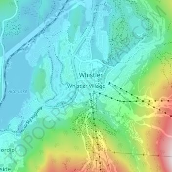
Name: Whistler Village topographic map, elevation, terrain.
Average elevation: 775 m
Minimum elevation: 637 m
Maximum elevation: 1,288 m
Thank you for supporting this site ❤️
Make a donation
Make a donation
Other topographic maps
Click on a map to view its topography, its elevation and its terrain.
Alta Lake
Canada > British Columbia > Squamish-Lillooet Regional District > Whistler > Whistler Village
Originally named Summit Lake, Alta Lake was renamed to avoid confusion with the many other Summit Lakes in British Columbia. The name is derived from the Spanish for "high up" or "upper". The lake's southern end is the divide between the basins of the Green and Cheakamus Rivers. The lake is 642 metres (2,106…
Average elevation: 726 m