
Triglav topographic map
Click on the map to display elevation.
Triglav
Triglav (pronounced [ˈtɾíːɡlaw]; German: Terglau; Italian: Tricorno), with an elevation of 2,863.65 metres (9,395 ft 2+1⁄8 in), is the highest mountain in Slovenia and the highest peak of the Julian Alps. The mountain is the pre-eminent symbol of the Slovene nation, appearing on the coat of arms and flag of Slovenia. It is the centrepiece of Triglav National Park, Slovenia's only national park. Triglav was also the highest peak in Yugoslavia before Slovenia's independence in 1991.
About this map
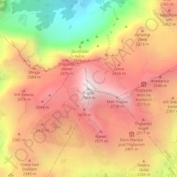
Name: Triglav topographic map, elevation, terrain.
Location: Triglav, Bohinj, Slovenia (46.37825 13.83653 46.37835 13.83663)
Average elevation: 2,161 m
Minimum elevation: 1,169 m
Maximum elevation: 2,835 m
Other topographic maps
Click on a map to view its topography, its elevation and its terrain.
Triglav National Park
Systematic surveys of plants, especially of ethnobotanically useful species, in Triglav National Park have been carried out by Chandra Prakash Kala and Petra Ratajc covering various microhabitats, elevations, aspects, and terrain types. The park has over fifty-nine species of ethnobotanical values, of these 37…
Average elevation: 1,063 m
Soča
An Alpine river in character, its source lies in the Trenta Valley in the Julian Alps in northwestern Slovenia, at an elevation of 876 metres (2,874 ft). The river runs past the towns of Bovec, Kobarid, Tolmin, Kanal ob Soči, Nova Gorica (where it is crossed by the Solkan Bridge), and Gorizia, entering the…
Average elevation: 562 m
Karst Plateau
It lies between the Vipava Valley, the low hills surrounding the valley, the westernmost part of the Brkini Hills, northern Istria, and the Gulf of Trieste. The western edge of the plateau also marks the traditional ethnic border between Italians and Slovenes. The region gave its name to karst topography. For…
Average elevation: 285 m
Piran / Pirano
The Municipality of Piran borders Croatia to the south and the municipalities of Izola and Koper to the east, and it faces Italy across the Gulf of Trieste and the Adriatic Sea. The highest point, Baretovec pri Padni, has an elevation of 289 meters (948 ft).
Average elevation: 33 m
Piran / Pirano
The Municipality of Piran borders Croatia to the south and the municipalities of Izola and Koper to the east, and it faces Italy across the Gulf of Trieste and the Adriatic Sea. The highest point, Baretovec pri Padni, has an elevation of 289 meters (948 ft).
Average elevation: 34 m