
Belfast topographic map
Interactive map
Click on the map to display elevation.
About this map
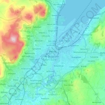
Name: Belfast topographic map, elevation, terrain.
Location: Belfast, County Antrim, Irlande du Nord, Royaume-Uni (54.53061 -6.04548 54.65942 -5.80769)
Average elevation: 92 m
Minimum elevation: -2 m
Maximum elevation: 476 m
Other topographic maps
Click on a map to view its topography, its elevation and its terrain.
Larne
Royaume-Uni > Irlande du Nord > County Antrim
Larne, County Antrim, Ulster, Irlande du Nord, BT40 1JS, Royaume-Uni
Average elevation: 54 m
Belfast
Royaume-Uni > Irlande du Nord > County Antrim
Belfast, County Antrim, Ulster, Irlande du Nord, BT1 5JD, Royaume-Uni
Average elevation: 87 m