
Thank you for supporting this site ❤️
Make a donation
Make a donation
Tavares topographic map
Click on the map to display elevation.
Thank you for supporting this site ❤️
Make a donation
Make a donation
About this map
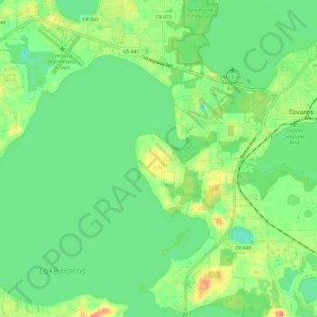
Name: Tavares topographic map, elevation, terrain.
Location: Tavares, Lake County, Florida, 32278, United States (28.74190 -81.78304 28.83820 -81.69152)
Average elevation: 24 m
Minimum elevation: 11 m
Maximum elevation: 50 m
Thank you for supporting this site ❤️
Make a donation
Make a donation
Other topographic maps
Click on a map to view its topography, its elevation and its terrain.
Thank you for supporting this site ❤️
Make a donation
Make a donation
Thank you for supporting this site ❤️
Make a donation
Make a donation
Thank you for supporting this site ❤️
Make a donation
Make a donation
Thank you for supporting this site ❤️
Make a donation
Make a donation
Thank you for supporting this site ❤️
Make a donation
Make a donation
Thank you for supporting this site ❤️
Make a donation
Make a donation
Lisbon
United States > Florida > Lake County
Lisbon has low rolling landscape with elevations ranging from 30 ft to 60 ft.
Average elevation: 22 m
Thank you for supporting this site ❤️
Make a donation
Make a donation
Thank you for supporting this site ❤️
Make a donation
Make a donation
Thank you for supporting this site ❤️
Make a donation
Make a donation