
Make a donation
Henderson County topographic map
Click on the map to display elevation.
Make a donation
Henderson County
Due to its geographic setting along the Eastern Continental Divide and its extreme topographic variation, Henderson County presents a wide variation in temperature and precipitation conditions. The highest elevations occur along the northwest and northern boundaries of the county and within the Blue Ridge Escarpment, a rugged area of peaks and narrow valleys that rise from the Piedmont to the continental divide and the Blue Ridge Plateau. The lowest elevations occur within the valleys of the escarpment and in the broader valleys of the Blue Ridge Plateau. The mean annual temperature of the county is 55.1 °F, with a range from 50.3 to 57.9 °F depending on the elevation, with higher temperatures occurring at lower elevations and lower temperatures in the higher mountains. The month of July is the hottest in the county, with a mean temperature of 72.6 °F and a mean range of 66.6 to 75.8 °F. The coolest month is January with a mean temperature of 36.9 °F and a mean range of 33.3 to 39.5 °F. Precipitation is also correlated to elevation, with higher precipitation normally occurring at higher elevations and lower precipitation in the valleys. The mean annual precipitation of Henderson County is 56.2 inches, with a mean range of 45.04 to 78.03 inches. March has the highest mean precipitation of 5.1 inches, with a mean range of 3.9 to 6.7 inches. The lowest precipitation occurs in October, with a mean value of 3.9 inches and a mean range of 2.8 to 5.8 inches.
Make a donation
About this map
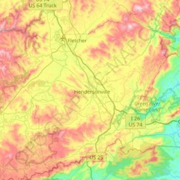
Name: Henderson County topographic map, elevation, terrain.
Location: Henderson County, North Carolina, United States (35.14419 -82.74515 35.50022 -82.26116)
Average elevation: 703 m
Minimum elevation: 276 m
Maximum elevation: 1,325 m
Make a donation
Other topographic maps
Click on a map to view its topography, its elevation and its terrain.
Appalachian Mountains
United States > North Carolina > Yancey County
The Appalachian Mountains (French: Appalaches), often called the Appalachians, are a system of mountains in eastern to northeastern North America. The Appalachians first formed roughly 480 million years ago during the Ordovician Period. They once reached elevations similar to those of the Alps and the Rocky…
Average elevation: 1,463 m
Bradley Creek Point
United States > North Carolina > New Hanover County > Wilmington
Average elevation: 3 m
Appalachian Mountains
United States > North Carolina > Yancey County
The Appalachian Mountains (French: Appalaches), often called the Appalachians, are a system of mountains in eastern to northeastern North America. The Appalachians first formed roughly 480 million years ago during the Ordovician Period. They once reached elevations similar to those of the Alps and the Rocky…
Average elevation: 1,463 m
Arden
United States > North Carolina > Buncombe County > Asheville > Royal Pines
Average elevation: 693 m
Make a donation
Highlands
United States > North Carolina > Macon County > Highlands
Highlands was founded in 1875 after its two founders, Samuel Truman Kelsey and Clinton Carter Hutchinson, drew lines from Chicago to Savannah and from New Orleans to New York City. They felt that the place where these lines met would eventually become a great trading center and commercial crossroads. Highlands…
Average elevation: 1,090 m
Make a donation
Lake Johnson
United States > North Carolina > Wake County > Raleigh > Orchards
Average elevation: 121 m
Mount Mitchell
United States > North Carolina > Yancey County
Mount Mitchell, known in Cherokee as Attakulla, is the highest peak of the Appalachian Mountains and the highest peak in mainland eastern North America. It is located near Burnsville in Yancey County, North Carolina in the Black Mountain subrange of the Appalachians about 19 miles (31 km) northeast of…
Average elevation: 1,743 m
Make a donation
Bald Head Island
United States > North Carolina > Brunswick County > Bald Head Island
Average elevation: 3 m
Make a donation
Make a donation
Make a donation
Little Switzerland
United States > North Carolina > McDowell County
Little Switzerland is an unincorporated community in McDowell and Mitchell counties of North Carolina, United States. It is located along North Carolina Highway 226A (NC 226A) off the Blue Ridge Parkway, directly north of Marion and south of Spruce Pine. The elevation is 3,468 feet (1,057 m) above sea level.
Average elevation: 935 m
Make a donation
Cataloochee Valley Viewpoint
United States > North Carolina > Haywood County > Cataloochee
Average elevation: 1,058 m
Make a donation
Make a donation
Kuwohi
United States > North Carolina > Swain County
At an elevation of 6,643 feet (2,025 m), it is the highest mountain in the Great Smoky Mountains National Park, the highest point in the state of Tennessee, and the highest point along the 2,192-mile (3,528 km) Appalachian Trail. It is also the third highest point in eastern mainland North America, after Mount…
Average elevation: 1,716 m
Lake Raleigh
United States > North Carolina > Wake County > Raleigh > Isle Forest
Average elevation: 104 m
Make a donation
Buckeye Lake
United States > North Carolina > Watauga County > Beech Mountain
Average elevation: 1,160 m
Make a donation
Ravensford
United States > North Carolina > Swain County > Yellowhill Community
Average elevation: 771 m
Make a donation
Elk Knob
United States > North Carolina > Watauga County
Elk Knob is a mountain in the North Carolina High Country, north of the community of Meat Camp. Its elevation reaches 5,538 feet (1,688 m).
Average elevation: 1,362 m
Make a donation
Make a donation
Make a donation
Make a donation
Parmele Isles
United States > North Carolina > New Hanover County > Wrightsville Beach
Average elevation: 1 m
Make a donation
Spring Valley
United States > North Carolina > Mecklenburg County > Charlotte
Average elevation: 201 m
Make a donation
Make a donation
Make a donation
Wolf Creek Lake
United States > North Carolina > Jackson County > Wolf Mountain
Average elevation: 1,021 m
Rich Mountain
United States > North Carolina > Watauga County
Rich Mountain is a mountain located in the North Carolina High Country, roughly 3 miles (4.8 km) northwest of the town of Boone. Its elevation reaches 4,748 feet (1,447 m).
Average elevation: 1,214 m
Make a donation
Make a donation
Make a donation
Make a donation
Make a donation