
Tullyglush topographic map
Interactive map
Click on the map to display elevation.
About this map
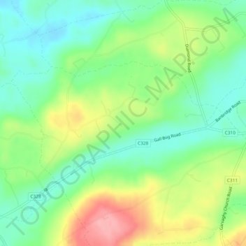
Name: Tullyglush topographic map, elevation, terrain.
Location: Tullyglush, Dromore, County Down, Irlande du Nord, Royaume-Uni (54.36843 -6.15897 54.38196 -6.12011)
Average elevation: 128 m
Minimum elevation: 84 m
Maximum elevation: 202 m
Other topographic maps
Click on a map to view its topography, its elevation and its terrain.
Ballyvicknacally
Royaume-Uni > Irlande du Nord > Dromore
Ballyvicknacally, Dromore, County Down, Irlande du Nord, Royaume-Uni
Average elevation: 106 m
Dromore
Royaume-Uni > Irlande du Nord > Dromore
Dromore, County Down, Irlande du Nord, BT25 1AN, Royaume-Uni
Average elevation: 106 m
Drumaghadone
Royaume-Uni > Irlande du Nord > Dromore
Drumaghadone, Dromore, County Down, Irlande du Nord, Royaume-Uni
Average elevation: 110 m