
Drumaghadone topographic map
Interactive map
Click on the map to display elevation.
About this map
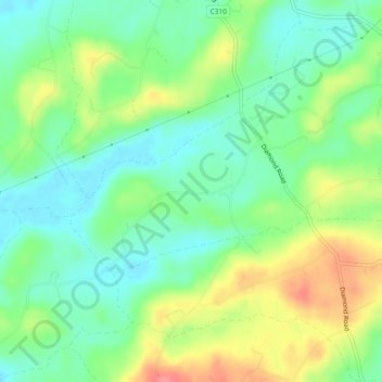
Name: Drumaghadone topographic map, elevation, terrain.
Average elevation: 110 m
Minimum elevation: 82 m
Maximum elevation: 157 m
Other topographic maps
Click on a map to view its topography, its elevation and its terrain.
Ballyvicknacally
Royaume-Uni > Irlande du Nord > Dromore
Ballyvicknacally, Dromore, County Down, Irlande du Nord, Royaume-Uni
Average elevation: 106 m
Dromore
Royaume-Uni > Irlande du Nord > Dromore
Dromore, County Down, Irlande du Nord, BT25 1AN, Royaume-Uni
Average elevation: 106 m
Tullyglush
Royaume-Uni > Irlande du Nord > Dromore
Tullyglush, Dromore, County Down, Irlande du Nord, Royaume-Uni
Average elevation: 128 m