
City of Zagreb topographic map
Interactive map
Click on the map to display elevation.
About this map
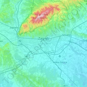
Name: City of Zagreb topographic map, elevation, terrain.
Location: City of Zagreb, Croatia (45.61395 15.77321 45.96915 16.23955)
Average elevation: 182 m
Minimum elevation: 96 m
Maximum elevation: 1,025 m
Zagreb (/ˈzɑːɡrɛb/ ZAH-greb Croatian: [zǎːɡreb] ) is the capital and largest city of Croatia. It is in the north of the country, along the Sava river, at the southern slopes of the Medvednica mountain. Zagreb stands near the international border between Croatia and Slovenia at an elevation of approximately 158 m (518 ft) above sea level. The population of the Zagreb urban agglomeration is 1,271,150, between a quarter and a third of the total population of Croatia, while at the 2021 census, the city itself had a population of 878,131.
Other topographic maps
Click on a map to view its topography, its elevation and its terrain.
Split
Croatia > Split-Dalmatia County
Split, Grad Split, Split-Dalmatia County, Croatia
Average elevation: 47 m
Maja
Croatia > Sisak-Moslavina County > Maja
Maja, Town of Glina, Sisak-Moslavina County, Croatia
Average elevation: 141 m
Trešnjevka - sjever
Trešnjevka - sjever, Zagreb, City of Zagreb, 10110, Croatia
Average elevation: 129 m
Donja Pušća
Donja Pušća, Općina Pušća, Zagreb County, 10294, Croatia
Average elevation: 187 m
Kaštel Sućurac
Kaštel Sućurac, Grad Kaštela, Split-Dalmatia County, 21212, Croatia
Average elevation: 183 m