
New Plymouth topographic map
Interactive map
Click on the map to display elevation.
About this map
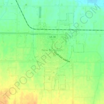
Name: New Plymouth topographic map, elevation, terrain.
Location: New Plymouth, Payette County, Idaho, 83655, United States (43.95968 -116.82670 43.97989 -116.80841)
Average elevation: 689 m
Minimum elevation: 673 m
Maximum elevation: 706 m
New Plymouth is located at 43°58′14″N 116°49′14″W / 43.97056°N 116.82056°W / 43.97056; -116.82056 (43.970689, -116.820449), at an elevation of 2,260 feet (689 m) above sea level.
Other topographic maps
Click on a map to view its topography, its elevation and its terrain.
Fruitland
United States > Idaho > Payette County
Fruitland, Payette County, Idaho, 83619, United States
Average elevation: 666 m
Ontario Island
United States > Idaho > Payette County
Ontario Island, Payette County, Idaho, United States
Average elevation: 655 m
Sand Hollow
United States > Idaho > Payette County
Sand Hollow, Payette County, Idaho, United States
Average elevation: 756 m