
Thank you for supporting this site ❤️
Make a donation
Make a donation
Ilo topographic map
Click on the map to display elevation.
Thank you for supporting this site ❤️
Make a donation
Make a donation
About this map
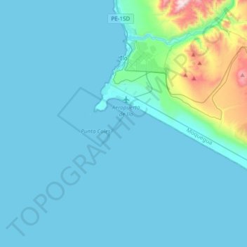
Name: Ilo topographic map, elevation, terrain.
Location: Ilo, Province of Ilo, Moquegua, Peru (-17.82148 -71.38145 -17.62107 -71.08199)
Average elevation: 101 m
Minimum elevation: 0 m
Maximum elevation: 1,104 m
Thank you for supporting this site ❤️
Make a donation
Make a donation
Other topographic maps
Click on a map to view its topography, its elevation and its terrain.
Thank you for supporting this site ❤️
Make a donation
Make a donation
Thank you for supporting this site ❤️
Make a donation
Make a donation
Toquepala Caves
Situated in the western Andes, they are in the Moquegua Region of the Osmore River. Located at an elevation of 2,200 m (7,200 ft) (2,800 m (9,200 ft) is also mentioned in another source[1]), they are two small caves each 15 m × 5 m (49 ft × 16 ft) in size, with a depth of 5 m (16 ft). The two Toquepala Caves…
Average elevation: 2,258 m