
Münzkirchen topographic map
Interactive map
Click on the map to display elevation.
About this map
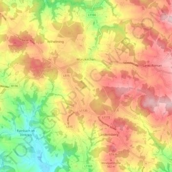
Name: Münzkirchen topographic map, elevation, terrain.
Location: Münzkirchen, Bezirk Schärding, 4792, Österreich (48.43932 13.54085 48.50823 13.62629)
Average elevation: 496 m
Minimum elevation: 346 m
Maximum elevation: 620 m
Münzkirchen liegt auf 486 m Höhe im Innviertel. Die Ausdehnung beträgt von Nord nach Süd 6,3 km, von West nach Ost 7,6 km. Die Gesamtfläche beträgt 21,03 km². 25,6 % der Fläche sind bewaldet, 65,9 % der Fläche sind landwirtschaftlich genutzt.
Other topographic maps
Click on a map to view its topography, its elevation and its terrain.
Vichtenstein
Vichtenstein, Bezirk Schärding, 4091, Österreich
Average elevation: 551 m
Andorf
Andorf, Bezirk Schärding, 4770, Österreich
Average elevation: 373 m
Enzenkirchen
Enzenkirchen, Bezirk Schärding, 4761, Österreich
Average elevation: 437 m
Taufkirchen an der Pram
Taufkirchen an der Pram, Bezirk Schärding, 4775, Österreich
Average elevation: 371 m
Schärding
Schärding, Bezirk Schärding, 4780, Österreich
Average elevation: 323 m
Kopfing im Innkreis
Kopfing im Innkreis, Bezirk Schärding, 4794, Österreich
Average elevation: 558 m