
Thank you for supporting this site ❤️
Make a donation
Make a donation
Vaterstetten topographic map
Click on the map to display elevation.
Thank you for supporting this site ❤️
Make a donation
Make a donation
About this map
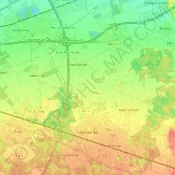
Name: Vaterstetten topographic map, elevation, terrain.
Location: Vaterstetten, Landkreis Ebersberg, Bavaria, Germany (48.08825 11.74770 48.15981 11.84503)
Average elevation: 536 m
Minimum elevation: 509 m
Maximum elevation: 561 m
Thank you for supporting this site ❤️
Make a donation
Make a donation
Other topographic maps
Click on a map to view its topography, its elevation and its terrain.
Thank you for supporting this site ❤️
Make a donation
Make a donation
Hesselfurt
Germany > Bavaria > Landkreis Ebersberg > Grafing > Grafing-Bahnhof
Average elevation: 541 m