Geolocate

Darmstadt topographic map

Click on the map to display elevation.

About this map

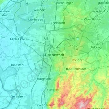
Name: Darmstadt topographic map, elevation, terrain.

Location: Darmstadt, Hesse, 64283, Germany (49.71278 8.49118 50.03278 8.81118)

Average elevation: 151 m

Minimum elevation: 82 m

Maximum elevation: 604 m

Other topographic maps

Click on a map to view its topography, its elevation and its terrain.

Rhön

Germany > Hesse

The High Rhön (German: Hohe Rhön or Hochrhön) is that part of the central Rhön that lies in Hesse, Bavaria, and to a lesser extent in Thuringia; it covers an area of 344 km2 (132.8 sq mi) Landscape fact files by the BfN (c.f. section on Natural region division) and is up to 950.0 m (3,117 ft) and whose…

Average elevation: 409 m

Bad Soden am Taunus

Germany > Hesse > Main-Taunus-Kreis

Average elevation: 216 m

Niedermeiser

Germany > Hesse > Landkreis Kassel

Average elevation: 231 m

34134

Germany > Hesse > Kassel

Average elevation: 170 m

Lauterborn

Germany > Hesse > Offenbach am Main

Average elevation: 119 m

60439

Germany > Hesse > Frankfurt

Average elevation: 128 m

34613

Germany > Hesse > Schwalm-Eder-Kreis > Treysa

Average elevation: 227 m

Schotten

Germany > Hesse > Vogelsbergkreis

Average elevation: 430 m

34628

Germany > Hesse > Schwalm-Eder-Kreis > Willingshausen

Average elevation: 253 m

34637

Germany > Hesse > Schwalm-Eder-Kreis > Schrecksbach

Average elevation: 256 m

Unter-Ostern

Germany > Hesse > Odenwaldkreis

Average elevation: 297 m

34233

Germany > Hesse > Landkreis Kassel > Simmershausen

Average elevation: 218 m

34639

Germany > Hesse > Schwalm-Eder-Kreis > Schwarzenborn

Average elevation: 523 m

34292

Germany > Hesse > Landkreis Kassel > Kammerberg

Average elevation: 275 m

34286

Germany > Hesse > Schwalm-Eder-Kreis > Spangenberg

Average elevation: 344 m

Usingen

Germany > Hesse > Hochtaunuskreis

The town core is about 300 m above sea level. The highest elevation in the main town of Usingen is the Hohe Berg ("High Mountain"), 414 m above sea level.

Average elevation: 356 m

Büdingen

Germany > Hesse > Wetteraukreis

Büdingen is in the south of the Wetterau below the Vogelsberg hills at an altitude of approx. 160 meters. The city is situated 15 km northwest of Gelnhausen and about 40 km east from Frankfurt am Main. Historically, the city belongs to Oberhessen.

Average elevation: 217 m

34119

Germany > Hesse > Kassel

Average elevation: 184 m

Nidda

Germany > Hesse

Average elevation: 204 m

37218

Germany > Hesse > Werra-Meißner-Kreis > Gertenbach

Average elevation: 222 m

Florstadt

Germany > Hesse > Wetteraukreis

Average elevation: 148 m

Bierstadt

Germany > Hesse > Wiesbaden

Average elevation: 191 m

65606

Germany > Hesse > Landkreis Limburg-Weilburg > Villmar

Average elevation: 185 m

Bergen-Enkheim

Germany > Hesse > Frankfurt

Average elevation: 142 m

Habitzheim

Germany > Hesse > Landkreis Darmstadt-Dieburg

Average elevation: 171 m

Oberzell

Germany > Hesse > Main-Kinzig-Kreis

Average elevation: 453 m

Heiligenrode

Germany > Hesse > Landkreis Kassel

Average elevation: 213 m

Wächtersbach

Germany > Hesse > Main-Kinzig-Kreis

Average elevation: 236 m

Kirchheim

Germany > Hesse > Landkreis Hersfeld-Rotenburg

Average elevation: 357 m

Niedermeilingen

Germany > Hesse > Rheingau-Taunus-Kreis

Average elevation: 369 m

Hochstadt

Germany > Hesse > Main-Kinzig-Kreis

Average elevation: 136 m

Korbach

Germany > Hesse > Landkreis Waldeck-Frankenberg

Average elevation: 389 m

Flörsheim

Germany > Hesse > Main-Taunus-Kreis

Average elevation: 111 m

Karben

Germany > Hesse > Wetteraukreis

Average elevation: 141 m

Odenwald

Germany > Hesse

Average elevation: 302 m

Taunusstein

Germany > Hesse > Rheingau-Taunus-Kreis

Average elevation: 392 m

Wixhausen

Germany > Hesse > Darmstadt

Average elevation: 143 m

Willingen (Upland)

Germany > Hesse > Willingen (Upland)

Average elevation: 591 m

Herborn

Germany > Hesse > Herborn

Average elevation: 331 m

Niedenstein

Germany > Hesse > Niedenstein

Average elevation: 292 m

Taunus

Germany > Hesse

Hintertaunus is the name given to the area north of the Hoher Taunus up to the Lahn valley. The landscape here is lower and less mountainous than in the southern Taunus. Between the valleys, some of which are quite deep, there are pronounced plateaus (leveled areas) with heavy agricultural use. Since mostly…

Average elevation: 280 m

Darmstadt

Germany > Hesse

Average elevation: 157 m

Ehrenberg

Germany > Hesse > Landkreis Fulda

Average elevation: 708 m

Offenbach am Main

Germany > Hesse

Average elevation: 118 m

Friedrichsdorf

Germany > Hesse > Friedrichsdorf

Average elevation: 226 m

Grebenstein

Germany > Hesse > Grebenstein

Average elevation: 227 m

Cölbe

Germany > Hesse > Landkreis Marburg-Biedenkopf > Cölbe

Average elevation: 245 m

Hofheim am Taunus

Germany > Hesse > Main-Taunus-Kreis

Hofheim is also described in the Topographia Hassiae.

Average elevation: 198 m

Braunfels

Germany > Hesse > Lahn-Dill-Kreis

Average elevation: 242 m

Hochheim

Germany > Hesse > Main-Taunus-Kreis

Average elevation: 123 m

Maintal

Germany > Hesse > Main-Kinzig-Kreis

Average elevation: 125 m

Limburg an der Lahn

Germany > Hesse > Landkreis Limburg-Weilburg > Limburg an der Lahn

The town lies roughly centrally in a basin within the Rhenish Slate Mountains which is surrounded by the low ranges of the Taunus and Westerwald and called the Limburg Basin (Limburger Becken). Owing to the favourable soil and climate, the Limburg Basin stands as one of Hesse's richest agricultural regions and…

Average elevation: 177 m

Oberzent

Germany > Hesse > Odenwaldkreis

Average elevation: 397 m

Oberems

Germany > Hesse > Hochtaunuskreis

Average elevation: 480 m

Main

Germany > Hesse > Kreis Groß-Gerau > Rüsselsheim am Main

Average elevation: 99 m

Michelstadt

Germany > Hesse > Odenwaldkreis

Average elevation: 358 m

Witzenhausen

Germany > Hesse > Werra-Meißner-Kreis

Average elevation: 297 m

Beerfelden

Germany > Hesse > Odenwaldkreis > Beerfelden

Beerfelden lies in the Odenwald at elevations from 330 to 540 m. Towards the south stretches the narrow, wooded Gammelsbach Valley, in which are found the Freienstein castle ruins, down to the Neckar.

Average elevation: 404 m

Nord (Holland)

Germany > Hesse > Kassel

Average elevation: 172 m

Heusenstamm

Germany > Hesse > Landkreis Offenbach

Average elevation: 133 m

Meißner

Germany > Hesse > Werra-Meißner-Kreis

Average elevation: 316 m