
Make a donation
Sudan topographic map
Click on the map to display elevation.
Make a donation
About this map
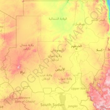
Name: Sudan topographic map, elevation, terrain.
Location: Sudan (7.08444 21.99177 22.08444 36.99177)
Average elevation: 602 m
Minimum elevation: 0 m
Maximum elevation: 3,207 m
Make a donation
Other topographic maps
Click on a map to view its topography, its elevation and its terrain.
Khartoum
In 1821, Khartoum was established 24 km (15 mi) north of the ancient city of Soba, by Isma'il Kamil Pasha, the third son of Egypt's ruler, Muhammad Ali Pasha, who had just incorporated Sudan into his realm. Originally, Khartoum served as an outpost for the Egyptian Army. Egypt shifted the seat of the colonial…
Average elevation: 384 m
Nyala
When the United Kingdom conquered present-day Sudan, the British commander-in-chief met Sultan Adam Suleiman in 1932, seeking his advice for his knowledge of the best places in terms of availability of water sources and land topography in order to establish the British Administration Headquarters in Darfur.…
Average elevation: 764 m
Make a donation
Make a donation
Nyala
When the United Kingdom conquered present-day Sudan, the British commander-in-chief met Sultan Adam Suleiman in 1932, seeking his advice for his knowledge of the best places in terms of availability of water sources and land topography in order to establish the British Administration Headquarters in Darfur.…
Average elevation: 764 m
Khartoum
In 1821, Khartoum was established 24 km (15 mi) north of the ancient city of Soba, by Isma'il Kamil Pasha, the third son of Egypt's ruler, Muhammad Ali Pasha, who had just incorporated Sudan into his realm. Originally, Khartoum served as an outpost for the Egyptian Army. Egypt shifted the seat of the colonial…
Average elevation: 384 m
Make a donation
Khartoum
Khartoum is relatively flat, at elevation 385 m (1,263 ft), as the Nile flows northeast past Omdurman to Shendi, at elevation 364 m (1,194 ft) about 101 miles (163 km) away.
Average elevation: 384 m
Make a donation
Make a donation
Make a donation
Make a donation
Make a donation
Make a donation
Make a donation
Make a donation
Make a donation
Make a donation
Make a donation
Make a donation
Make a donation
Singa
Singa (Arabic: سنجة) is a town located in the Sennar State of Sudan at an elevation of 439 meters (1,440 feet) above sea level. The town is situated on the west bank of the Blue Nile at a distance of 360 kilometers (220 miles) to the southeast of the capital, Khartoum, and 60 kilometers from Sennar city.…
Average elevation: 462 m
Make a donation
Make a donation
Make a donation
Make a donation
Make a donation