
Thank you for supporting this site ❤️
Make a donation
Make a donation
Måbøberget topographic map
Click on the map to display elevation.
Thank you for supporting this site ❤️
Make a donation
Make a donation
About this map
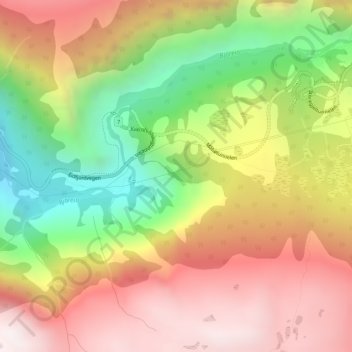
Name: Måbøberget topographic map, elevation, terrain.
Location: Måbøberget, Eidfjord, Vestland, Norway (60.41792 7.21521 60.41802 7.21531)
Average elevation: 709 m
Minimum elevation: 169 m
Maximum elevation: 1,189 m
Thank you for supporting this site ❤️
Make a donation
Make a donation
Other topographic maps
Click on a map to view its topography, its elevation and its terrain.