
Tbilisi topographic map
Interactive map
Click on the map to display elevation.
About this map
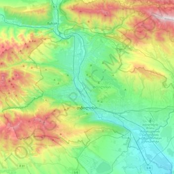
Name: Tbilisi topographic map, elevation, terrain.
Location: Tbilisi, Georgia (41.61779 44.59620 41.83762 45.01729)
Average elevation: 752 m
Minimum elevation: 330 m
Maximum elevation: 1,713 m
Most of the raions are named after historic quarters of the city. The citizens of Tbilisi widely recognise an informal system of smaller historic neighborhoods. Such neighborhoods are several, however, constituting a kind of hierarchy, because most of them have lost their distinctive topographic limits. The natural first level of subdivision of the city is into the right and left banks of the Mtkvari river.
Other topographic maps
Click on a map to view its topography, its elevation and its terrain.
Shovi
Georgia > Racha-Lechkhumi and Lower Svaneti > Oni Municipality
Shovi, Oni Municipality, Racha-Lechkhumi and Lower Svaneti, Georgia
Average elevation: 1,792 m
Zhabeshi
Georgia > Samegrelo-Upper Svaneti > Zhabeshi
Zhabeshi, Mestia Municipality, Samegrelo-Upper Svaneti, Georgia
Average elevation: 1,990 m
Tsaneri Glacier
Georgia > Samegrelo-Upper Svaneti
Tsaneri Glacier, Mestia Municipality, Samegrelo-Upper Svaneti, Georgia
Average elevation: 3,592 m
Ushba
Georgia > Samegrelo-Upper Svaneti
Ushba, Mestia Municipality, Samegrelo-Upper Svaneti, Georgia
Average elevation: 3,640 m
Stepantsminda
Georgia > Mtskheta-Mtianeti > Stepantsminda
Stepantsminda, Kazbegi Municipality, Mtskheta-Mtianeti, Georgia
Average elevation: 1,855 m
Caucasus Mountains
Caucasus Mountains, Dusheti Municipality, Mtskheta-Mtianeti, Georgia
Average elevation: 2,188 m
Mount Mkinvartsveri (Kazbegi)
Mount Mkinvartsveri (Kazbegi), Kazbegi Municipality, Mtskheta-Mtianeti, Georgia
Average elevation: 4,324 m