
Make a donation
Toowoomba topographic map
Click on the map to display elevation.
Make a donation
Toowoomba
The city is situated on the edge of the range and the low ridges behind it. Two valleys extend north from the southern boundary, originating from springs on either side of Middle Ridge near Spring Street, at an altitude of approximately 680 metres (2,230 ft). These waterways, East Creek and West Creek, converge just north of the CBD to form Gowrie Creek.
Make a donation
About this map
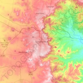
Name: Toowoomba topographic map, elevation, terrain.
Location: Toowoomba, Toowoomba Regional, Queensland, 4350, Australia (-27.72102 151.79335 -27.40102 152.11335)
Average elevation: 458 m
Minimum elevation: 126 m
Maximum elevation: 736 m
Make a donation
Other topographic maps
Click on a map to view its topography, its elevation and its terrain.
Lama Lama National Park (Cape York Peninsula Aboriginal Land)
Average elevation: 86 m
Make a donation
Make a donation
Make a donation
Make a donation
City of Brisbane
Brisbane's topography is characterized by a series of hills and ranges that define its landscape. The city is situated on a low-lying floodplain, with the Brisbane River meandering through its heart, creating a winding course with many steep curves from the southwest to its mouth at Moreton Bay in the east.…
Average elevation: 71 m
Make a donation
Sunshine Coast Regional
The Sunshine Coast Regional area in Queensland, Australia, features a diverse topography that ranges from coastal plains to rugged hinterlands. Along the coastline, the terrain is predominantly flat, with average elevations around 20 meters (66 feet) above sea level. Inland, the landscape transitions to…
Average elevation: 56 m
Make a donation
Brisbane River
The RAAF also perform a practice session in the days preceding the event, serving as an opportunity to both practice beforehand and also promote Riverfire. One of the most popular RAAF aircraft to perform at Riverfire was the F-111 which was known for performing a 'dump-and-burn' above the city. The final…
Average elevation: 235 m
Make a donation
Make a donation
Make a donation
Make a donation
Lamb Island
Australia > Queensland > Brisbane
The island is in the southern part of Moreton Bay between the Queensland mainland and North Stradbroke Island. It is within the Moreton Bay Marine Park. The elevation ranges from 0 to 26 metres (0 to 85 ft) above sea level. The land use on the island is predominantly residential.
Average elevation: 4 m
City of Brisbane
Brisbane's topography is characterized by a series of hills and ranges that define its landscape. The city is situated on a low-lying floodplain, with the Brisbane River meandering through its heart, creating a winding course with many steep curves from the southwest to its mouth at Moreton Bay in the east.…
Average elevation: 71 m
Make a donation
Make a donation
Make a donation
Make a donation
Make a donation
Make a donation
Make a donation
Make a donation
Make a donation
Make a donation
Make a donation
Make a donation
Make a donation
Make a donation
Make a donation