
Make a donation
Leader topographic map
Click on the map to display elevation.
Make a donation
About this map
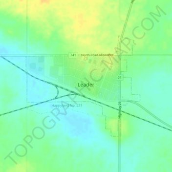
Name: Leader topographic map, elevation, terrain.
Location: Leader, Saskatchewan, S0N 1H0, Canada (50.87970 -109.55986 50.89546 -109.53147)
Average elevation: 674 m
Minimum elevation: 662 m
Maximum elevation: 688 m
Make a donation
Other topographic maps
Click on a map to view its topography, its elevation and its terrain.
Saskatoon
Saskatoon lies on a long belt of rich, potassic chernozem in middle-southern Saskatchewan and is found in the aspen parkland biome. The lack of surrounding mountainous topography gives the city a relatively flat grid, though the city does sprawl over a few hills and into a few valleys. The lowest point in the…
Average elevation: 504 m
Regina
Unlike other planned cities in the Canadian West, on its treeless flat plain Regina has few topographical features other than the small spring run-off, Wascana Creek. Early planners took advantage of such opportunity by damming the creek to create a decorative lake to the south of the central business district…
Average elevation: 582 m
Make a donation
Make a donation
Make a donation
Make a donation
Make a donation
Make a donation
Make a donation
Make a donation
Make a donation
Make a donation
Make a donation
Make a donation
Make a donation
Make a donation
Make a donation
Make a donation
Make a donation
Prince Albert National Park
About 90% of the park is in the Waskesiu Hills and elevations range from 488 m (1,601 ft) on the western side to 724 m (2,375 ft) on the eastern side. There are several large lakes in the park, including Waskesiu, Kingsmere, and Crean, and several notable rivers have their source there, such as Spruce,…
Average elevation: 557 m
Make a donation
Make a donation
Make a donation
Make a donation
Make a donation
Make a donation
Make a donation
Make a donation