
Thank you for supporting this site ❤️
Make a donation
Make a donation
Loborika topographic map
Click on the map to display elevation.
Thank you for supporting this site ❤️
Make a donation
Make a donation
About this map
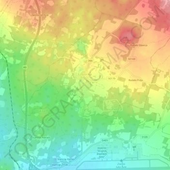
Name: Loborika topographic map, elevation, terrain.
Location: Loborika, община Марчана, Истрийская жупания, Хорватия (44.89334 13.88496 44.93437 13.93994)
Average elevation: 102 m
Minimum elevation: 47 m
Maximum elevation: 166 m
Thank you for supporting this site ❤️
Make a donation
Make a donation
Other topographic maps
Click on a map to view its topography, its elevation and its terrain.