
Tillot topographic map
Interactive map
Click on the map to display elevation.
About this map
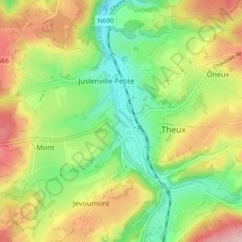
Name: Tillot topographic map, elevation, terrain.
Location: Tillot, Theux, Verviers, Liège, Wallonie, 4910, Belgique (50.51721 5.79023 50.55721 5.83023)
Average elevation: 236 m
Minimum elevation: 143 m
Maximum elevation: 360 m
Other topographic maps
Click on a map to view its topography, its elevation and its terrain.
Vert Buisson
Belgique > Liège > Verviers > Theux
Vert Buisson, La Reid, Theux, Verviers, Liège, Wallonie, 4910, Belgique
Average elevation: 403 m
Haute Desnié
Belgique > Liège > Verviers > Theux
Haute Desnié, La Reid, Theux, Verviers, Liège, Wallonie, 4910, Belgique
Average elevation: 412 m
Hauts Marais
Belgique > Liège > Verviers > Theux
Hauts Marais, La Reid, Theux, Verviers, Liège, Wallonie, 4910, Belgique
Average elevation: 353 m