
Make a donation
Erith topographic map
Click on the map to display elevation.
Make a donation
About this map
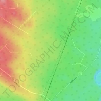
Name: Erith topographic map, elevation, terrain.
Location: Erith, Yellowhead County, Alberta, Canada (53.40667 -116.69333 53.42667 -116.67333)
Average elevation: 985 m
Minimum elevation: 938 m
Maximum elevation: 1,034 m
Make a donation
Other topographic maps
Click on a map to view its topography, its elevation and its terrain.
Brazeau River Provincial Recreation Area
Canada > Alberta > Yellowhead County
Average elevation: 1,325 m
Make a donation
William A. Switzer Provincial Park
Canada > Alberta > Yellowhead County
This park is situated within the foothills of Alberta's Rocky Mountains, at an elevation of 1,150 m (3,770 ft) to 1,300 m (4,300 ft) and has a surface of 93 km2 (36 sq mi). It was established on December 22, 1958 and is maintained by Alberta Tourism, Parks and Recreation. The park is named after former…
Average elevation: 1,348 m