
Make a donation
Gunzwil topographic map
Click on the map to display elevation.
Make a donation
About this map
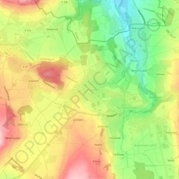
Name: Gunzwil topographic map, elevation, terrain.
Location: Gunzwil, Beromünster, Lucerne, 6222, Switzerland (47.19167 8.16005 47.23167 8.20005)
Average elevation: 671 m
Minimum elevation: 563 m
Maximum elevation: 778 m
Make a donation
Other topographic maps
Click on a map to view its topography, its elevation and its terrain.
Make a donation
Kriens
The eastern part of Kriens (the districts near the city and near Horw) lie in a valley. From Kupferhammer the land gently rises to the west, toward Obernau (elevation difference between Kupferhammer and Obernau less than 90 m (300 ft) ).
Average elevation: 705 m
Make a donation
Kriens
The eastern part of Kriens (the districts near the city and near Horw) lie in a valley. From Kupferhammer the land gently rises to the west, toward Obernau (elevation difference between Kupferhammer and Obernau less than 90 m (300 ft) ).
Average elevation: 705 m
Weggis
The town of Weggis lies on a south-facing plain on the shore of Lake Lucerne. Formerly, the town consisted of only two communities, Unterdorf in the west and Oberdorf in the east. Because of development in the last decades, new communities have developed: Hinterdorf (east of Oberdorf), Rain and Laugneri (near…
Average elevation: 651 m
Make a donation
Make a donation
Make a donation
Make a donation