
Thank you for supporting this site ❤️
Make a donation
Make a donation
Suiderstrand topographic map
Click on the map to display elevation.
Thank you for supporting this site ❤️
Make a donation
Make a donation
About this map
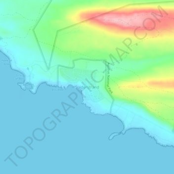
Name: Suiderstrand topographic map, elevation, terrain.
Average elevation: 34 m
Minimum elevation: -1 m
Maximum elevation: 157 m
Thank you for supporting this site ❤️
Make a donation
Make a donation
Other topographic maps
Click on a map to view its topography, its elevation and its terrain.
Struisbaai
South Africa > Western Cape > Cape Agulhas Local Municipality > Molshoop
Average elevation: 27 m
Struisbaai
South Africa > Western Cape > Cape Agulhas Local Municipality > Molshoop
Average elevation: 27 m