
Thank you for supporting this site ❤️
Make a donation
Make a donation
Amarakaeri Communal Reserve topographic map
Click on the map to display elevation.
Thank you for supporting this site ❤️
Make a donation
Make a donation
About this map
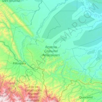
Name: Amarakaeri Communal Reserve topographic map, elevation, terrain.
Location: Amarakaeri Communal Reserve, Madre de Dios, Peru (-13.27725 -71.33258 -12.30882 -70.49334)
Average elevation: 760 m
Minimum elevation: 241 m
Maximum elevation: 4,163 m
Thank you for supporting this site ❤️
Make a donation
Make a donation
Other topographic maps
Click on a map to view its topography, its elevation and its terrain.