
Make a donation
Gyeonggi topographic map
Click on the map to display elevation.
Make a donation
Gyeonggi
The topography of Gyeonggi Province is divided into southern and northern areas by the Han River, which flows from east to west. The area north to the Han River is mainly mountainous, while the southern area is mainly plain.
Make a donation
About this map
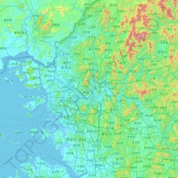
Name: Gyeonggi topographic map, elevation, terrain.
Location: Gyeonggi, South Korea (36.89378 126.27795 38.28111 127.84811)
Average elevation: 144 m
Minimum elevation: -3 m
Maximum elevation: 1,431 m
Make a donation
Other topographic maps
Click on a map to view its topography, its elevation and its terrain.
Make a donation
Make a donation
Dokdo-ri
The Liancourt Rocks, known in Korea as Dokdo (Korean: 독도) and in Japan as Takeshima (Japanese: 竹島), are a group of islets in the Sea of Japan between the Korean Peninsula and the Japanese archipelago administered by South Korea. The Liancourt Rocks comprise two main islets and 35 smaller rocks; the…
Average elevation: 0 m
Make a donation
Make a donation
Make a donation
Make a donation
Make a donation
Make a donation
Make a donation
Make a donation
Make a donation
Make a donation
Make a donation
Make a donation
Make a donation
Make a donation
Make a donation
Make a donation
Make a donation
Make a donation
Make a donation
Turczaninow Hornbeam Tree at Chamseongdan Altar
South Korea > Ganghwa-gun > Incheon > Hwado-myeon
Average elevation: 155 m
Make a donation
Make a donation
Make a donation
Make a donation