
Wetzikon (ZH) topographic map
Interactive map
Click on the map to display elevation.
About this map
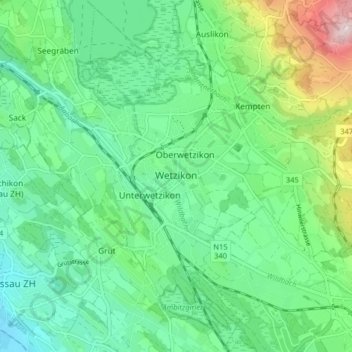
Name: Wetzikon (ZH) topographic map, elevation, terrain.
Location: Wetzikon (ZH), Bezirk Hinwil, Zurich, Suisse (47.29621 8.76357 47.34884 8.84434)
Average elevation: 563 m
Minimum elevation: 452 m
Maximum elevation: 867 m
Other topographic maps
Click on a map to view its topography, its elevation and its terrain.
Fischenthal
Suisse > Zurich > Bezirk Hinwil
Fischenthal, Bezirk Hinwil, Zurich, Suisse
Average elevation: 863 m