
Make a donation
Haute Matsiatra topographic map
Click on the map to display elevation.
Make a donation
About this map
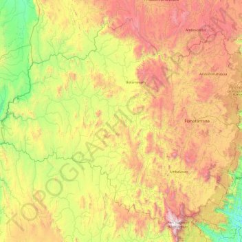
Name: Haute Matsiatra topographic map, elevation, terrain.
Location: Haute Matsiatra, Province de Fianarantsoa, Madagascar (-22.23832 45.50344 -20.70259 47.45000)
Average elevation: 948 m
Minimum elevation: 87 m
Maximum elevation: 2,627 m
Make a donation
Other topographic maps
Click on a map to view its topography, its elevation and its terrain.
Antsirabe
Madagascar > Vakinankaratra > Antsirabe I
Antsirabe is situated at an altitude of about 1,500 m (4,900 ft), making its subtropical highland climate (Köppen: Cwb), similar to Brazilian high cities of the southeast. During the winter the temperature can fall below 0 °C (32 °F) at night, and Antsirabe has recorded the lowest temperature in Madagascar…
Average elevation: 1,671 m
Make a donation
Make a donation
Antananarivo
Antananarivo (Malagasy: [antananaˈrivʷ]; French: Tananarive, pronounced [tananaʁiv]), also known by its colonial shorthand form Tana (pronounced [tana]), is the capital and largest city of Madagascar. The administrative area of the city, known as Antananarivo-Renivohitra ("Antananarivo-Mother Hill" or…
Average elevation: 1,309 m
Marojejy National Park
Madagascar > Antsiranana Province > District de Sambava
Marojejy National Park (/məˈroʊdʒɛdʒiː/) is a national park in the Sava region of northeastern Madagascar. It covers 55,500 ha (214 sq mi) and is centered on the Marojejy Massif, a mountain chain that rises to an elevation of 2,132 m (6,995 ft). Access to the area around the massif was restricted to…
Average elevation: 675 m
Make a donation
Réserve Naturelle Intégrale des Tsingy de Bemaraha
Madagascar > Melaky > Antsalova
Average elevation: 103 m
Make a donation
Make a donation
Make a donation
Make a donation
Make a donation
Antananarivo
Antananarivo (Malagasy: [antananaˈrivʷ]; French: Tananarive, pronounced [tananaʁiv]), also known by its colonial shorthand form Tana (pronounced [tana]), is the capital and largest city of Madagascar. The administrative area of the city, known as Antananarivo-Renivohitra ("Antananarivo-Mother Hill" or…
Average elevation: 1,309 m
Make a donation
Nosy Komba
Madagascar > Diana Region > Ampangorina
French settler-colonial efforts on Nosy Be were persistently hampered by outbreaks of diseases such as malaria, cholera, and smallpox. To remedy this, a convalescence for French settlers was built on the adjacent Nosy Komba in 1841, immediately following the French annexation of the region, with an upgraded…
Average elevation: 133 m
Make a donation
Antananarivo
Antananarivo (Malagasy: [antananaˈrivʷ]; French: Tananarive, pronounced [tananaʁiv]), also known by its colonial shorthand form Tana (pronounced [tana]), is the capital and largest city of Madagascar. The administrative area of the city, known as Antananarivo-Renivohitra ("Antananarivo-Mother Hill" or…
Average elevation: 1,309 m
Make a donation
Antsirabe
Antsirabe is situated at an altitude of about 1,500 m (4,900 ft), making its subtropical highland climate (Köppen: Cwb), similar to Brazilian high cities of the southeast. During the winter the temperature can fall below 0 °C (32 °F) at night, and Antsirabe has recorded the lowest temperature in Madagascar…
Average elevation: 1,671 m
Make a donation
Make a donation
Make a donation
Isalo National Park
Madagascar > Ihorombe > Ranohira
Isalo National Park is a National Park in the Ihorombe Region of Madagascar, in the southwestern corner of the Province of Fianarantsoa. The closest town is Ranohira, and the closest cities are Toliara and Ihosy. It is a sandstone landscape that has been dissected by wind and water erosion into rocky outcrops,…
Average elevation: 803 m
Make a donation
Antananarivo
Antananarivo (French: Tananarive, pronounced [tananaʁiv]), also known by its colonial shorthand form Tana, is the capital and largest city of Madagascar. The administrative area of the city, known as Antananarivo-Renivohitra ("Antananarivo-Mother Hill" or "Antananarivo-Capital"), is the capital of Analamanga…
Average elevation: 1,309 m
Antsirabe
Antsirabe is situated at an altitude of about 1,500 m (4,900 ft), making its subtropical highland climate (Köppen: Cwb), similar to Brazilian high cities of the southeast. During the winter the temperature can fall below 0 °C (32 °F) at night, and Antsirabe has recorded the lowest temperature in Madagascar…
Average elevation: 1,671 m
Make a donation
Make a donation
Fianarantsoa
Madagascar > Haute Matsiatra > District de Fianarantsoa > Fianarantsoa
Average elevation: 1,201 m
Make a donation