
Thank you for supporting this site ❤️
Make a donation
Make a donation
Ice topographic map
Click on the map to display elevation.
Thank you for supporting this site ❤️
Make a donation
Make a donation
About this map
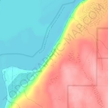
Name: Ice topographic map, elevation, terrain.
Location: Ice, Alger County, Michigan, United States (46.45668 -86.58963 46.45678 -86.58953)
Average elevation: 226 m
Minimum elevation: 174 m
Maximum elevation: 283 m
Thank you for supporting this site ❤️
Make a donation
Make a donation
Other topographic maps
Click on a map to view its topography, its elevation and its terrain.
Pictured Rocks National Lakeshore (Inner Buffer Zone)
United States > Michigan > Alger County > Munising Township
Average elevation: 220 m
Thank you for supporting this site ❤️
Make a donation
Make a donation