
Thank you for supporting this site ❤️
Make a donation
Make a donation
Mayhill topographic map
Click on the map to display elevation.
Thank you for supporting this site ❤️
Make a donation
Make a donation
About this map
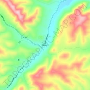
Name: Mayhill topographic map, elevation, terrain.
Location: Mayhill, Otero County, New Mexico, United States (32.86954 -105.49804 32.90954 -105.45804)
Average elevation: 2,104 m
Minimum elevation: 1,974 m
Maximum elevation: 2,255 m
Thank you for supporting this site ❤️
Make a donation
Make a donation
Other topographic maps
Click on a map to view its topography, its elevation and its terrain.
Timberon
United States > New Mexico > Otero County
Timberon is located at 32°37′54″N 105°41′32″W / 32.63167°N 105.69222°W / 32.63167; -105.69222 (32.631675, -105.692254). Timberon is located in a forested valley, known as Sacramento Canyon, on the southern slopes of the Sacramento Mountains. The Sacramento Creek, an intermittent creek,…
Average elevation: 2,217 m