
Make a donation
Timberon topographic map
Click on the map to display elevation.
Make a donation
Timberon
Timberon is located at 32°37′54″N 105°41′32″W / 32.63167°N 105.69222°W / 32.63167; -105.69222 (32.631675, -105.692254). Timberon is located in a forested valley, known as Sacramento Canyon, on the southern slopes of the Sacramento Mountains. The Sacramento Creek, an intermittent creek, flows southeast through the valley. The community extends up several crosscutting canyons including Arkansas Canyon, Graveyard Canyon and Carrisa Canyon. The elevation in Timberon varies from 6,900 to 7,200 feet. Jefferies Peak at 8,501 feet (2,591 m) is located directly to the east of the valley, and Culp Peak at 7,280 feet (2,219 m) lies to the west.
Make a donation
About this map
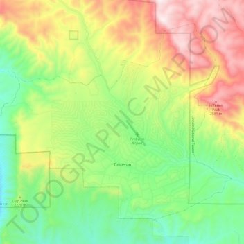
Name: Timberon topographic map, elevation, terrain.
Location: Timberon, Otero County, New Mexico, 88350, United States (32.59715 -105.76047 32.67977 -105.63984)
Average elevation: 2,217 m
Minimum elevation: 1,881 m
Maximum elevation: 2,693 m
Make a donation
Other topographic maps
Click on a map to view its topography, its elevation and its terrain.