
Make a donation
Baco topographic map
Click on the map to display elevation.
Make a donation
Baco
Majority of the barangays of the municipality are in lowland areas or below 500 meters above sea level (MASL) and cover 41.88 percent of the total land area (13,035.58 ha). The three largest barangays, which cover most of the forestland, have an elevation that ranges from 500-1,000 and greater than 1,000 meters above sea level. Moreover, Mount Halcon, which is found in Bayanan and Lantuyang, has the highest elevation in the entire province of Oriental Mindoro with an estimated height of 2,590 meters above sea level.
Make a donation
About this map
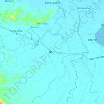
Name: Baco topographic map, elevation, terrain.
Location: Baco, Oriental Mindoro, Mimaropa, Philippines (13.31810 121.05633 13.39810 121.13633)
Average elevation: 14 m
Minimum elevation: 0 m
Maximum elevation: 204 m
Make a donation
Other topographic maps
Click on a map to view its topography, its elevation and its terrain.
Calapan
Philippines > Oriental Mindoro
The overall land characteristic is a wide plain with rivers, interspersed with wetlands at the seacoast periphery. The highest elevation is 187 m (614 ft) above sea level at Bulusan Hill, a 6-kilometre (3.7 mi) long landform east of the city, which interrupts the mostly flat terrain north-east of the…
Average elevation: 12 m
Make a donation
Naujan Lake
Philippines > Oriental Mindoro > Malabo
Mount Naujan, elevation 1,380 feet (420 m) and one of the inactive volcanoes of the country, is situated northeast of the geographic center of the lake. Several thermal springs and solfataras are reported to exist on the eastern border of the Naujan Lake.
Average elevation: 46 m
Make a donation
Make a donation
Calapan
Philippines > Oriental Mindoro
The overall land characteristic is a wide plain with rivers, interspersed with wetlands at the seacoast periphery. The highest elevation is 187 m (614 ft) above sea level at Bulusan Hill, a 6-kilometre (3.7 mi) long landform east of the city, which interrupts the mostly flat terrain north-east of the…
Average elevation: 12 m
Make a donation
San Teodoro
Philippines > Oriental Mindoro
Lt. Hutchins saw that the topographic location of Subaan proper was not suitable for future municipal site expansion. The place was surrounded by nipa swamps and marshland, and the shores were muddy and rocky. He asked Pres. Juan Rojas if they could find a broader place for the town site. The president…
Average elevation: 578 m