
Thank you for supporting this site ❤️
Make a donation
Make a donation
Loskop topographic map
Click on the map to display elevation.
Thank you for supporting this site ❤️
Make a donation
Make a donation
About this map
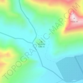
Name: Loskop topographic map, elevation, terrain.
Average elevation: 561 m
Minimum elevation: 385 m
Maximum elevation: 1,043 m
Thank you for supporting this site ❤️
Make a donation
Make a donation
Other topographic maps
Click on a map to view its topography, its elevation and its terrain.
Breede River
South Africa > Western Cape > Cape Winelands District Municipality > Breede Valley Local Municipality
Average elevation: 219 m
Hex River
South Africa > Western Cape > Cape Winelands District Municipality > Breede Valley Local Municipality
Average elevation: 644 m