
Tukituki River topographic map
Interactive map
Click on the map to display elevation.
About this map
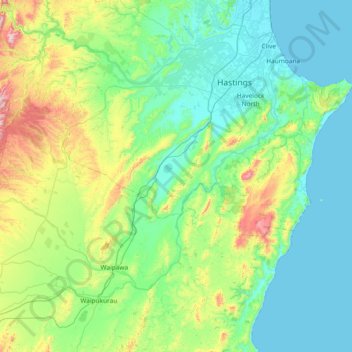
Name: Tukituki River topographic map, elevation, terrain.
Location: Tukituki River, Hawke's Bay, 4295, Nouvelle-Zélande (-39.98966 176.20302 -39.59841 176.94554)
Average elevation: 153 m
Minimum elevation: 0 m
Maximum elevation: 756 m
Other topographic maps
Click on a map to view its topography, its elevation and its terrain.
Wairoa District
Nouvelle-Zélande > Hawke's Bay
Wairoa District, Hawke's Bay, Nouvelle-Zélande
Average elevation: 327 m