
Wairoa District topographic map
Interactive map
Click on the map to display elevation.
About this map
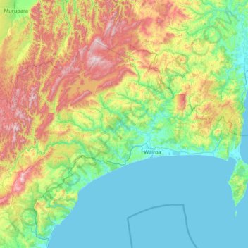
Name: Wairoa District topographic map, elevation, terrain.
Location: Wairoa District, Hawke's Bay, Nouvelle-Zélande (-39.26525 176.69203 -38.58392 178.00178)
Average elevation: 327 m
Minimum elevation: -1 m
Maximum elevation: 1,365 m
Other topographic maps
Click on a map to view its topography, its elevation and its terrain.
Tukituki River
Nouvelle-Zélande > Hawke's Bay
Tukituki River, Hawke's Bay, 4295, Nouvelle-Zélande
Average elevation: 153 m