
Labuerda/A Buerda topographic map
Interactive map
Click on the map to display elevation.
About this map
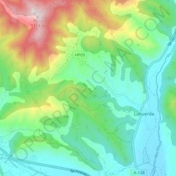
Name: Labuerda/A Buerda topographic map, elevation, terrain.
Location: Labuerda/A Buerda, Sobrarbe, Huesca, Aragón, Spanje (42.43088 0.08501 42.48504 0.14175)
Average elevation: 759 m
Minimum elevation: 538 m
Maximum elevation: 1,287 m
Other topographic maps
Click on a map to view its topography, its elevation and its terrain.
San Juan de Plan/San Chuan de Plan
San Juan de Plan/San Chuan de Plan, Sobrarbe, Huesca, Aragón, 22367, Spanje
Average elevation: 1,974 m
Aínsa
Spanje > Aragón > Sobrarbe > Aínsa-Sobrarbe/L´Aínsa-Sobrarbe
Aínsa, Aínsa-Sobrarbe/L´Aínsa-Sobrarbe, Sobrarbe, Huesca, Aragón, 22330, Spanje
Average elevation: 596 m
Aínsa-Sobrarbe/L´Aínsa-Sobrarbe
Aínsa-Sobrarbe/L´Aínsa-Sobrarbe, Sobrarbe, Huesca, Aragón, Spanje
Average elevation: 762 m
Griebal
Spanje > Aragón > Sobrarbe > Aínsa-Sobrarbe/L´Aínsa-Sobrarbe
Griebal, Aínsa-Sobrarbe/L´Aínsa-Sobrarbe, Sobrarbe, Huesca, Aragón, 22337, Spanje
Average elevation: 665 m