
Galán topographic map
Interactive map
Click on the map to display elevation.
About this map
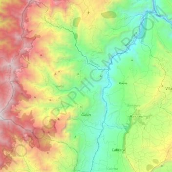
Name: Galán topographic map, elevation, terrain.
Location: Galán, Santander, Kolumbien (6.56508 -73.39887 6.78345 -73.25821)
Average elevation: 1,628 m
Minimum elevation: 344 m
Maximum elevation: 3,341 m
Other topographic maps
Click on a map to view its topography, its elevation and its terrain.
Bucaramanga
Kolumbien > Santander > Bucaramanga
Bucaramanga, Santander, 680003, Kolumbien
Average elevation: 1,348 m