
Lac Wanaka topographic map
Interactive map
Click on the map to display elevation.
About this map
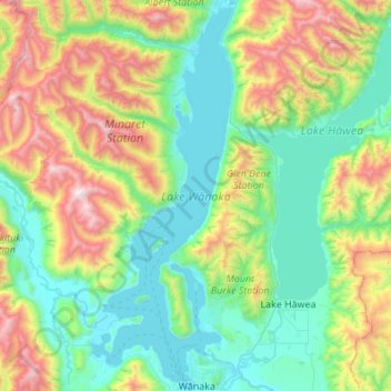
Name: Lac Wanaka topographic map, elevation, terrain.
Average elevation: 812 m
Minimum elevation: 273 m
Maximum elevation: 2,304 m
Le lac Wanaka est un lac de l'île du Sud en Nouvelle-Zélande, située dans la région d'Otago à une altitude de 300 m. Recouvrant 192 km2, il est le quatrième plus grand lac de la Nouvelle-Zélande. Sa profondeur maximale est estimée à 300 m.
Other topographic maps
Click on a map to view its topography, its elevation and its terrain.
Mount Pisa
Nouvelle-Zélande > Otago > Queenstown-Lakes District
Mount Pisa, Queenstown-Lakes District, Otago, Nouvelle-Zélande
Average elevation: 1,739 m
Queenstown
Nouvelle-Zélande > Otago > Queenstown-Lakes District
Queenstown, Queenstown-Lakes District, Otago, 9348, Nouvelle-Zélande
Average elevation: 592 m
Arrowtown
Nouvelle-Zélande > Otago > Queenstown-Lakes District
Arrowtown, Queenstown-Lakes District, Otago, 9302, Nouvelle-Zélande
Average elevation: 671 m