
Thank you for supporting this site ❤️
Make a donation
Make a donation
Toshima Island topographic map
Click on the map to display elevation.
Thank you for supporting this site ❤️
Make a donation
Make a donation
About this map
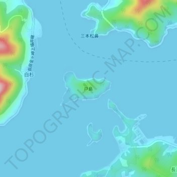
Name: Toshima Island topographic map, elevation, terrain.
Location: Toshima Island, Maizuru, Kyoto Prefecture, Japan (35.49351 135.33830 35.49875 135.34789)
Average elevation: 21 m
Minimum elevation: -2 m
Maximum elevation: 246 m
Thank you for supporting this site ❤️
Make a donation
Make a donation