
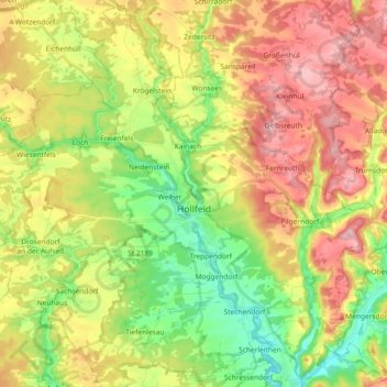
Hollfeld topographic map
Interactive map
Click on the map to display elevation.
About this map
Name: Hollfeld topographic map, elevation, terrain.
Average elevation: 449 m
Minimum elevation: 360 m
Maximum elevation: 552 m
Kern der historischen Altstadt ist der Marienplatz auf einer Anhöhe über der Stadt. Vor dem Oberen Tor steht die barocke Nepomuk-Kapelle aus dem Jahr 1734.
Other topographic maps
Click on a map to view its topography, its elevation and its terrain.
Rosenhof
Deutschland > Bayern > Landkreis Bayreuth > Pegnitz
Rosenhof, Pegnitz, Landkreis Bayreuth, Bayern, 91257, Deutschland
Average elevation: 475 m
Heßlach
Deutschland > Bayern > Landkreis Bayreuth > Weidenberg
Heßlach, Weidenberg, Weidenberg (VGem), Landkreis Bayreuth, Bayern, 95466, Deutschland
Average elevation: 538 m
Mistelbach
Deutschland > Bayern > Landkreis Bayreuth
Mistelbach, Mistelbach (VGem), Landkreis Bayreuth, Bayern, 95511, Deutschland
Average elevation: 409 m
Fröbershammer
Deutschland > Bayern > Landkreis Bayreuth
Fröbershammer, Bischofsgrün, Landkreis Bayreuth, Bayern, 95493, Deutschland
Average elevation: 757 m