
Fröbershammer topographic map
Interactive map
Click on the map to display elevation.
About this map
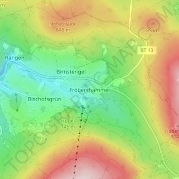
Name: Fröbershammer topographic map, elevation, terrain.
Average elevation: 757 m
Minimum elevation: 607 m
Maximum elevation: 954 m
Birnstengel | Bischofsgrün | Eichig | Fröbershammer | Glasermühle | Göhren | Güßhügel | Hedlerreuth | Hirschhaid | Hohehaid | Höhenklinik Bischofsgrün | Karches | Neuhaus | Rangen | Wülfersreuth
Other topographic maps
Click on a map to view its topography, its elevation and its terrain.
Hollfeld
Deutschland > Bayern > Landkreis Bayreuth
Hollfeld, Hollfeld (VGem), Landkreis Bayreuth, Bayern, 96142, Deutschland
Average elevation: 449 m
Rosenhof
Deutschland > Bayern > Landkreis Bayreuth > Pegnitz
Rosenhof, Pegnitz, Landkreis Bayreuth, Bayern, 91257, Deutschland
Average elevation: 475 m
Heßlach
Deutschland > Bayern > Landkreis Bayreuth > Weidenberg
Heßlach, Weidenberg, Weidenberg (VGem), Landkreis Bayreuth, Bayern, 95466, Deutschland
Average elevation: 538 m
Mistelbach
Deutschland > Bayern > Landkreis Bayreuth
Mistelbach, Mistelbach (VGem), Landkreis Bayreuth, Bayern, 95511, Deutschland
Average elevation: 409 m