
Nkam topographic map
Interactive map
Click on the map to display elevation.
About this map
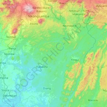
Name: Nkam topographic map, elevation, terrain.
Location: Nkam, LT, +237, Cameroun (4.06670 9.75608 5.10754 10.65274)
Average elevation: 403 m
Minimum elevation: -1 m
Maximum elevation: 2,354 m
Other topographic maps
Click on a map to view its topography, its elevation and its terrain.
Communauté urbaine de Douala
Communauté urbaine de Douala, Wouri, LT, Cameroun
Average elevation: 13 m