
Thank you for supporting this site ❤️
Make a donation
Make a donation
Kangding topographic map
Click on the map to display elevation.
Thank you for supporting this site ❤️
Make a donation
Make a donation
About this map
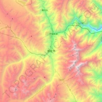
Name: Kangding topographic map, elevation, terrain.
Location: Kangding, Kangding City, Sichuan, 626000, China (29.84142 101.79482 30.16142 102.11482)
Average elevation: 3,942 m
Minimum elevation: 1,730 m
Maximum elevation: 6,018 m
Thank you for supporting this site ❤️
Make a donation
Make a donation
Other topographic maps
Click on a map to view its topography, its elevation and its terrain.