
Make a donation
Southend topographic map
Click on the map to display elevation.
Make a donation
About this map
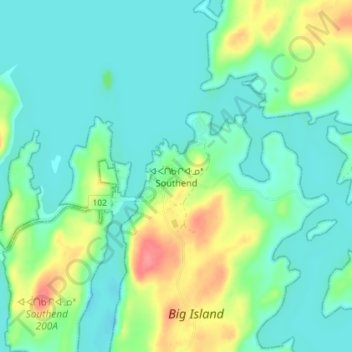
Name: Southend topographic map, elevation, terrain.
Location: Southend, Saskatchewan, Canada (56.30925 -103.25869 56.34925 -103.21869)
Average elevation: 350 m
Minimum elevation: 331 m
Maximum elevation: 398 m
Make a donation
Other topographic maps
Click on a map to view its topography, its elevation and its terrain.
Saskatoon
Saskatoon lies on a long belt of rich, potassic chernozem in middle-southern Saskatchewan and is found in the aspen parkland biome. The lack of surrounding mountainous topography gives the city a relatively flat grid, though the city does sprawl over a few hills and into a few valleys. The lowest point in the…
Average elevation: 504 m
Regina
Unlike other planned cities in the Canadian West, on its treeless flat plain Regina has few topographical features other than the small spring run-off, Wascana Creek. Early planners took advantage of such opportunity by damming the creek to create a decorative lake to the south of the central business district…
Average elevation: 582 m
Make a donation
Make a donation
Make a donation
Make a donation
Make a donation
Make a donation
Make a donation
Regina
Unlike other planned cities in the Canadian West, on its treeless flat plain, Regina has few topographical features other than the small spring run-off, Wascana Creek. Early planners took advantage of such opportunity by damming the creek to create a decorative lake to the south of the central business…
Average elevation: 582 m
Make a donation
Make a donation
Make a donation
Make a donation
Make a donation
Make a donation
Make a donation
Make a donation
Make a donation
Make a donation
Make a donation
Make a donation
Make a donation
Make a donation
Make a donation
Make a donation
Primrose Lake
Canada > Saskatchewan > Unorganized Division No. 18
Primrose Lake has a total surface area of 444 km2 (171 sq mi), 17.7 km2 (6.8 sq mi) of which is in Alberta, and an elevation of 559 metres (1,834 ft). It lies within muskeg and the boreal forest ecozone of Canada. There are several rivers and creeks that flow into the lake with Calder River on the northern…
Average elevation: 607 m
Cranberry Flats Conservation Area
Canada > Saskatchewan > Corman Park No. 344
Average elevation: 495 m
Make a donation
Buffalo Pound Lake
Canada > Saskatchewan > Marquis No. 191 > South Lake
Buffalo Pound Lake is a eutrophic prairie lake formed from glacial melt about 10,000 years ago on the Qu'Appelle River in Saskatchewan, Canada. It is located approximately 28 kilometres (17 mi) north of Moose Jaw and 11 kilometres (6.8 mi) north-east of Tuxford. The lake gets its name from the method used by…
Average elevation: 581 m
Make a donation