
Make a donation
Cala Gonone topographic map
Click on the map to display elevation.
Make a donation
About this map
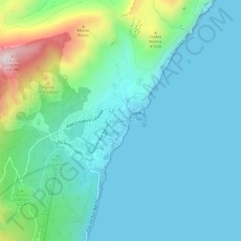
Name: Cala Gonone topographic map, elevation, terrain.
Location: Cala Gonone, Durgali/Dorgali, Nuoro, Sardinia, 08022, Italy (40.26209 9.61434 40.30209 9.65434)
Average elevation: 141 m
Minimum elevation: 0 m
Maximum elevation: 723 m
Make a donation
Other topographic maps
Click on a map to view its topography, its elevation and its terrain.
Make a donation
Parco nazionale del Golfo di Orosei e del Gennargentu
Average elevation: 634 m
Orane/Orani
Orani sits at an altitude of 526 meters, at the foot of Mount Gonare, in the heart of the Barbagia region. Among the notable archaeological sites in the area are approximately 30 nuraghi and several giants' graves. The Sanctuary of Our Lady of Gonare at the crest of the mountain is of particular interest, as…
Average elevation: 505 m
Make a donation
Make a donation
Make a donation
Orane/Orani
Orani sits at an altitude of 526 meters, at the foot of Mount Gonare, in the heart of the Barbagia region. Among the notable archaeological sites in the area are approximately 30 nuraghi and several “tombs of the giants”. The Sanctuary of Our Lady of Gonare at the crest of the mountain is of particular…
Average elevation: 505 m
Make a donation