
Thank you for supporting this site ❤️
Make a donation
Make a donation
Lanusei topographic map
Click on the map to display elevation.
Thank you for supporting this site ❤️
Make a donation
Make a donation
About this map
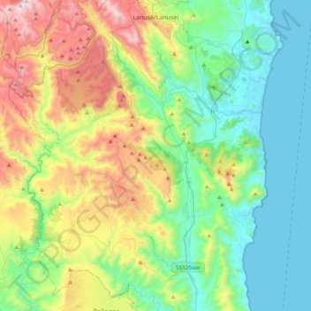
Name: Lanusei topographic map, elevation, terrain.
Location: Lanusei, Nuoro, Sardinia, 08045, Italy (39.60305 9.49021 39.89425 9.65529)
Average elevation: 388 m
Minimum elevation: 0 m
Maximum elevation: 1,314 m
Thank you for supporting this site ❤️
Make a donation
Make a donation
Other topographic maps
Click on a map to view its topography, its elevation and its terrain.