
Tamuín topographic map
Interactive map
Click on the map to display elevation.
About this map
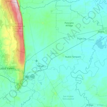
Name: Tamuín topographic map, elevation, terrain.
Location: Tamuín, San Luis Potosi, Mexico (21.75467 -98.91882 22.40893 -98.48971)
Average elevation: 86 m
Minimum elevation: 1 m
Maximum elevation: 823 m
Other topographic maps
Click on a map to view its topography, its elevation and its terrain.
Estación Tamuín
Mexico > San Luis Potosi > Tamuín > Estación Tamuín
Estación Tamuín, Tamuín, San Luis Potosi, Mexico
Average elevation: 35 m